

Where have all the cornfields gone, long time passing?
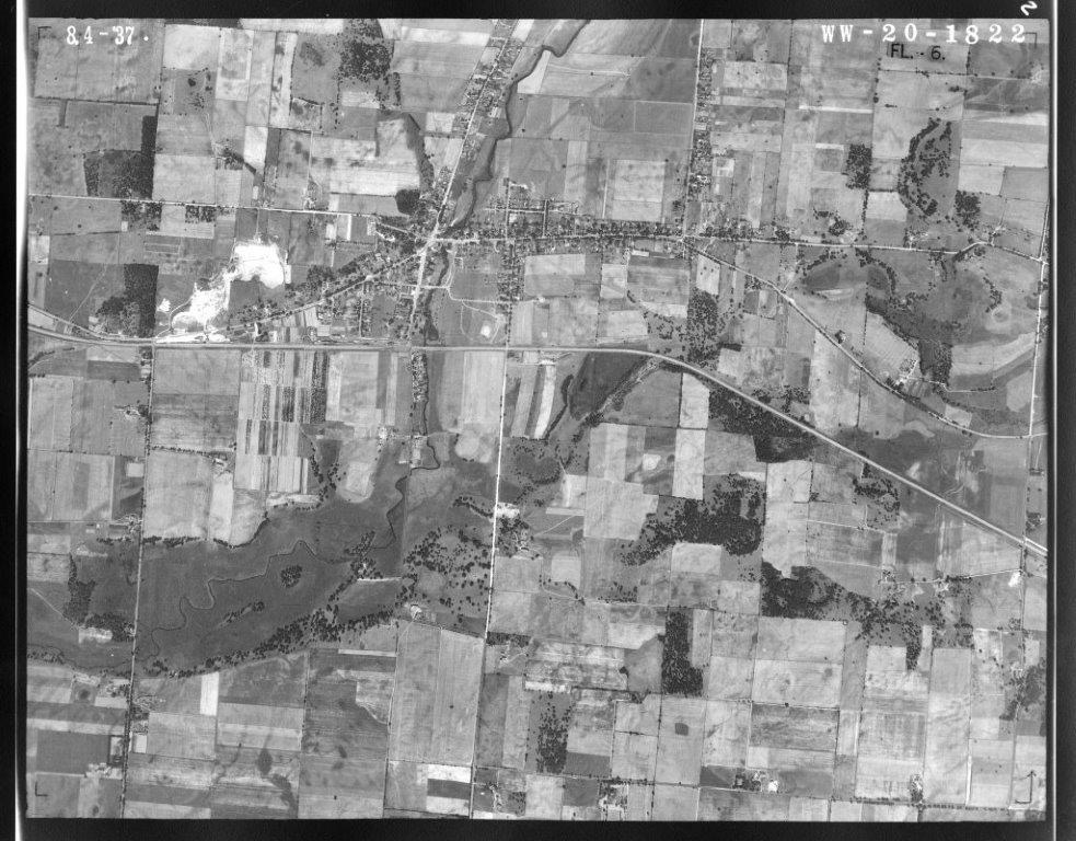
The Village of Hartland 1937
One “Smart Growth” plan after another over the years has resulted in the elimination of any agricultural land in the Village; the Sanctuary of Hartland being the last to undergo the zoning alchemy. Local developers know that the Village will be more than happy to annex any neighboring land to add another subdivision, as we saw with Four Winds West and Windrush. The Corporation needs to survive and what better way to do it than by increasing the municipal tax base. To that end, a large part of the Village bureaucracy appears to be dedicated to the care and nurture of subdivision developers.
Yet, if you recall the analysis I did of the Village of Hartland Comprehensive Development Plan: 2035, the responses to the community surveys that served as the basis for the plan were overwhelmingly for the preservation of natural areas and open spaces. Given the relentless development that has ensued since the plan was adopted in 2010, and the fact that much of the data referenced in the plan was pre-2000, the Village should honor the commitment they made to review the entire plan within 5 years; not for the purpose of undoing any of the development that has occurred, which would be impossible, but to highlight the need to balance the scales by applying Village resources to the protection and preservation of the environmental corridor and natural spaces.
Since my appointment to the Village’s “Environmental Corridor and Open Spaces Task Force”, I’ve been trying to learn what is actually happening on the lands in the Village. No less than 5 new subdivision developments have commenced, or significantly advanced, since 2010: Sanctuary of Hartland, Windrush, Homestead, Four Winds West, and the North Forty.
 The image above is from the 2009 “Smart Growth” plan in which the Village planners made no secret of their intentions regarding the Sanctuary, Homestead and North Forty subdivisions; Windrush and Four Winds West were just twinkling in the eyes of the developers back then. Where have all the cornfields gone? They are still visible on Google Map, but you better hurry as I’m sure it will be updated soon.
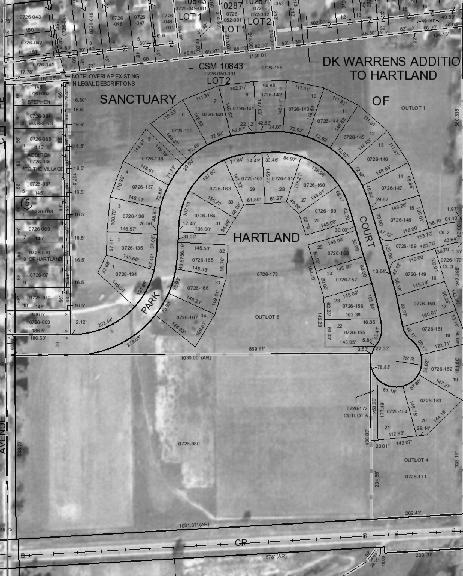
 The Sanctuary of Hartland was farmland before they planted the pine plantation in the 70’s. You can see the new subdivision plat laid over a 1941 aerial image below.
 To the existing home owners surrounding this area, some of whose homes date back to the 1937 era, this area was literally a sanctuary in their backyards; maybe that is why they showed up at Village Board meetings to protest — in vain. I haven’t heard of any protests against any of the other new subdivisions, and it will be too late when residents see the new assessments for water and sewer services.
“Unless a productive use can be found for woodlands or other upland open spaces in and around the Village, they may as well be developed.”: 65% strongly disagreed, 27% disagreed. Comprehensive Development Plan: 2035 Appendix B
Well, that’s the response Hartland residents gave in the community survey and below we see what they got in return:


“Concept Plan for Windrush Subdivision” Jim Siepmann of Siepmann Realty said he expects to have the 57-lot Windrush subdivision built by the end of the year. The subdivision, located south of Highway K near Winkleman Road, is considered part one of a three part development plan.


North Forty
Who am I to question the powers that be? A nobody, but, isn’t it obvious how out of balance the Village of Hartland is? After extolling the value and importance of the environment and natural spaces, and the need to protect and preserve them in their Comprehensive Development Plan: 2035, the Village’s Boards, Commissions and Departments have spent relatively little time or resources following through on those goals. Developing subdivisions is very complicated; it absorbs a lot of attention within the Village Bureaucracy. Imagine if even a fraction of that effort were dedicated to the environmental corridor — starting with Village owned land?
So, where have all the cornfields gone? Well, there is still a cornfield in Hartland!
 Yup, it’s right smack dab in the primary environmental corridor on a parcel of Village Land that is zoned parks and recreation. Some Village Board members would like to see a Community Center or some other public facility built here. This has been debated for a long time and the prospects are uncertain. In the meantime, why not make this land The Hartland Prairie — fitting in with the environmental corridor — instead of The Hartland Cornfield?

The Hartland Cornfield
A living museum

Don’t worry about the weeds; this GMO corn is Roundup ready!
The Village leadership views this parcel as extremely valuable land, and while they try to figure out what to do with it, they have been leasing it to a farmer to grow corn and soybeans — ignoring their own zoning ordinance. Never mind all the supplicants who appear before the Architecture and Planning Commission and the Village Board to request zoning changes or variances, they rightly fall under the jurisdiction of the Village of Hartland (I love the etymology of that word: jurisdiction, juris/law + diction/to speak = To Speak the Law). The law applies to you, not the Village!
Well, I really needed to pull those weeds out of my mind. Are you still with me? Thanks!
I’ve been focused on garlic mustard and dames rocket lately. Here are a few pics from my recent weed pulling adventures at The Hartland Marsh.


Back at The Springs, I had the pleasure of leading a Natural Resources Foundation Hike at The Scuppernong Springs Nature Trail on National Trails Day with Dr. Dan Carter from SEWRPC and special guests Pati Holman and Lindsay Knudsvig.


Later that afternoon, per advice from Dan, I transplanted some roundleaf monkeyflower (Mimulus glabratus) that I had harvested a couple days earlier from Mckeawn Spring and Bluff Creek to the spring just below the Scuppernong Spring.


I hope the transplants root!
Then I went to the Indian Spring to pull watercress and plant some more roundleaf monkeyflower. It would be great if we could replace the invasive, non-native, watercress with a native plant like roundleaf monkeyflower.


Some parting shots from The Springs and Ottawa Lake.


See you at The Springs!
